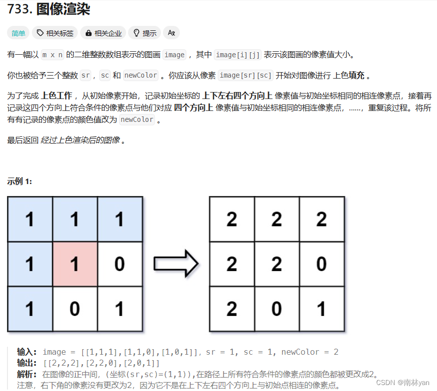
👽发现宝藏
前些天发现了一个巨牛的人工智能学习网站,通俗易懂,风趣幽默,忍不住分享一下给大家。【点击进入巨牛的人工智能学习网站】。
当我们谈论计算机编程中的地图生成时,通常会想到游戏开发、仿真模拟或者数据可视化等领域。Python 作为一门功能强大的编程语言,在地图生成方面有着丰富的资源和库。本文将介绍如何使用 Python 中的一些工具和库来绘制随机地形地图。
准备工作
在开始之前,我们需要确保安装了 Python 和一些必要的库。这里我们将使用 matplotlib 库来绘制地图,以及 numpy 库来生成随机地形。你可以通过以下命令来安装这些库:
pip install matplotlib numpy
生成随机地形
首先,我们需要生成随机的地形数据。这里我们将使用 numpy 库中的随机数生成函数来生成一个二维数组,代表地形的高度。
import numpy as np

def generate_terrain(width, height, scale=20, octaves=6, persistence=0.5, lacunarity=2.0, seed=None):
    if seed is not None:
        np.random.seed(seed)

    terrain = np.zeros((height, width))
    for y in range(height):
        for x in range(width):
            amplitude = 1
            frequency = 1
            for o in range(octaves):
                sampleX = x / scale * frequency
                sampleY = y / scale * frequency

                noise = np.interp([sampleX], [0, 1], [-1, 1]) * 2 - 1
                terrain[y][x] += noise * amplitude

                amplitude *= persistence
                frequency *= lacunarity
    return terrain
这段代码使用了 Perlin 噪声算法来生成随机地形数据。通过调整参数,我们可以控制生成地形的复杂程度。
绘制地图
接下来,我们将使用 matplotlib 库来绘制生成的地形数据。
import matplotlib.pyplot as plt

def plot_terrain(terrain):
    plt.figure(figsize=(10, 5))
    plt.imshow(terrain, cmap='terrain', origin='lower')
    plt.colorbar(label='Elevation')
    plt.title('Terrain Map')
    plt.xlabel('X')
    plt.ylabel('Y')
    plt.show()

# 生成地形数据
width = 100
height = 100
terrain = generate_terrain(width, height)

# 绘制地图
plot_terrain(terrain)
这段代码将生成的地形数据以热图的形式展示出来。你可以看到地形的高低起伏,颜色越亮代表海拔越高,颜色越暗代表海拔越低。
添加地形特征
除了简单的随机地形外,我们还可以添加一些地形特征,如山脉、河流等,使地图更加生动。
生成山脉
我们可以通过在地形中添加高度较高的区域来模拟山脉。
def add_mountains(terrain, num_mountains=5, mountain_height=10, seed=None):
    if seed is not None:
        np.random.seed(seed)

    height, width = terrain.shape
    for _ in range(num_mountains):
        peak_x = np.random.randint(0, width)
        peak_y = np.random.randint(0, height)
        radius = np.random.randint(10, 30)
        for y in range(height):
            for x in range(width):
                distance_to_peak = np.sqrt((x - peak_x)**2 + (y - peak_y)**2)
                if distance_to_peak < radius:
                    terrain[y][x] += mountain_height * np.exp(-distance_to_peak / (radius / 3))
生成河流
河流是地形中常见的地形特征之一,我们可以在地图中模拟出河流的路径。
def add_river(terrain, river_width=3, river_depth=5, seed=None):
    if seed is not None:
        np.random.seed(seed)

    height, width = terrain.shape
    start_x = np.random.randint(0, width)
    start_y = 0
    end_x = np.random.randint(0, width)
    end_y = height - 1

    current_x = start_x
    current_y = start_y

    while current_y < end_y:
        next_x = np.clip(current_x + np.random.randint(-1, 2), 0, width - 1)
        current_y += 1
        for x in range(max(0, next_x - river_width // 2), min(width, next_x + river_width // 2)):
            for y in range(max(0, current_y - river_width // 2), min(height, current_y + river_width // 2)):
                terrain[y][x] -= river_depth
        current_x = next_x
完整代码
将上述的地形特征生成函数与前文的地形生成函数结合起来,并进行绘图:
terrain = generate_terrain(width, height)
add_mountains(terrain)
add_river(terrain)

plot_terrain(terrain)
通过这些地形特征的添加,我们可以生成更加多样化和丰富的地形地图。这些地图不仅可以用于游戏开发中的世界地图生成,还可以用于模拟实验中的地理环境,或者作为数据可视化的一部分呈现地形信息。 Python 的强大库和灵活性使得地图生成变得轻而易举。
自定义地形特征
除了山脉和河流之外,我们还可以添加其他类型的地形特征,比如湖泊、峡谷等,来使地图更加多样化。
生成湖泊
湖泊是由于低洼地区积水而形成的地形特征,我们可以在地图中随机选择一些低洼的区域并将其填充成湖泊。
def add_lakes(terrain, num_lakes=3, lake_size=10, lake_depth=5, seed=None):
    if seed is not None:
        np.random.seed(seed)

    height, width = terrain.shape
    for _ in range(num_lakes):
        lake_x = np.random.randint(0, width)
        lake_y = np.random.randint(0, height)
        for y in range(max(0, lake_y - lake_size), min(height, lake_y + lake_size)):
            for x in range(max(0, lake_x - lake_size), min(width, lake_x + lake_size)):
                terrain[y][x] -= lake_depth
生成峡谷
峡谷是由于地质构造而形成的地形特征,我们可以模拟出峡谷两侧的陡峭山壁。
def add_canyons(terrain, num_canyons=2, canyon_width=5, canyon_depth=10, seed=None):
    if seed is not None:
        np.random.seed(seed)

    height, width = terrain.shape
    for _ in range(num_canyons):
        start_x = np.random.randint(0, width)
        start_y = np.random.randint(0, height)
        direction_x = np.random.choice([-1, 1])
        direction_y = np.random.choice([-1, 1])

        for step in range(canyon_width):
            current_x = start_x + step * direction_x
            current_y = start_y + step * direction_y
            for y in range(max(0, current_y - canyon_width), min(height, current_y + canyon_width)):
                for x in range(max(0, current_x - canyon_width), min(width, current_x + canyon_width)):
                    terrain[y][x] -= canyon_depth * (1 - step / canyon_width)
完整代码
将上述的地形特征生成函数与前文的地形生成函数结合起来,并进行绘图:
terrain = generate_terrain(width, height)
add_mountains(terrain)
add_river(terrain)
add_lakes(terrain)
add_canyons(terrain)

plot_terrain(terrain)
通过添加不同的地形特征,我们可以生成更加多样化和复杂的地形地图,从而满足不同应用场景下的需求。这些地形地图不仅可以提供视觉上的享受,还可以用于模拟实验、游戏开发、数据可视化等各种用途。 Python 的灵活性和丰富的库使得地图生成变得简单而有趣。
进一步优化地形生成算法
在前面的代码中,我们使用了简单的 Perlin 噪声算法来生成随机地形数据。虽然这种方法可以生成较为自然的地形,但在一些情况下可能会出现连续性不够好、地形过于平滑等问题。为了进一步优化地形生成的质量,我们可以考虑使用更复杂的地形生成算法,例如 Diamond-Square 算法。
Diamond-Square 算法是一种递归的地形生成算法,它通过不断地对方形区域进行分割和计算来生成地形。这种算法生成的地形具有更好的连续性和细节性,能够更好地模拟真实世界中的地形特征。
下面是一个简化版的 Diamond-Square 算法的实现示例:
def diamond_square_algorithm(size, roughness=0.5, seed=None):
    if seed is not None:
        np.random.seed(seed)

    terrain = np.zeros((size, size))
    step_size = size - 1

    # 初始化角点高度
    terrain[0][0] = np.random.uniform(0, 1)
    terrain[0][size - 1] = np.random.uniform(0, 1)
    terrain[size - 1][0] = np.random.uniform(0, 1)
    terrain[size - 1][size - 1] = np.random.uniform(0, 1)

    while step_size > 1:
        half_step = step_size // 2

        # Diamond 步骤
        for y in range(0, size - 1, step_size):
            for x in range(0, size - 1, step_size):
                average = (terrain[y][x] + terrain[y][x + step_size] + terrain[y + step_size][x] + terrain[y + step_size][x + step_size]) / 4
                terrain[y + half_step][x + half_step] = average + np.random.uniform(-roughness, roughness)

        # Square 步骤
        for y in range(0, size - 1, half_step):
            for x in range((y + half_step) % step_size, size - 1, step_size):
                average = 0
                count = 0
                if y - half_step >= 0:
                    average += terrain[y - half_step][x]
                    count += 1
                if y + half_step < size:
                    average += terrain[y + half_step][x]
                    count += 1
                if x - half_step >= 0:
                    average += terrain[y][x - half_step]
                    count += 1
                if x + half_step < size:
                    average += terrain[y][x + half_step]
                    count += 1
                terrain[y][x] = average / count + np.random.uniform(-roughness, roughness)

                if x == 0:
                    terrain[y][size - 1] = average / count + np.random.uniform(-roughness, roughness)
                if y == 0:
                    terrain[size - 1][x] = average / count + np.random.uniform(-roughness, roughness)

        step_size //= 2
        roughness /= 2

    return terrain
使用 Diamond-Square 算法生成地形
现在,我们可以使用 Diamond-Square 算法来生成地形,并绘制地图:
terrain = diamond_square_algorithm(size=128, roughness=0.7, seed=42)
plot_terrain(terrain)
通过 Diamond-Square 算法生成的地形具有更多的细节和更好的连续性,能够更好地模拟真实世界中的地形特征。这使得我们可以生成更加真实和多样化的地形地图,满足不同应用场景下的需求。
自定义地形特征
在生成地形之后,我们可以进一步增强地图的真实感和趣味性,通过添加自定义的地形特征,比如树木、建筑物等。
生成树木
树木是地图中常见的地形特征,我们可以随机在地图的某些位置生成树木,使得地图更加生动。
def add_trees(terrain, num_trees=50, min_height=0.3, max_height=0.8, seed=None):
    if seed is not None:
        np.random.seed(seed)

    height, width = terrain.shape
    for _ in range(num_trees):
        tree_x = np.random.randint(0, width)
        tree_y = np.random.randint(0, height)
        if terrain[tree_y][tree_x] > min_height:
            terrain[tree_y][tree_x] += np.random.uniform(0, max_height - min_height)
生成建筑物
建筑物是地图中的人工结构,可以通过随机在地图上生成一些方块状的结构来模拟建筑物的存在。
def add_buildings(terrain, num_buildings=10, min_height=0.5, max_height=0.9, building_size=5, seed=None):
    if seed is not None:
        np.random.seed(seed)

    height, width = terrain.shape
    for _ in range(num_buildings):
        building_x = np.random.randint(0, width - building_size)
        building_y = np.random.randint(0, height - building_size)
        building_height = np.random.uniform(min_height, max_height)
        terrain[building_y:building_y+building_size, building_x:building_x+building_size] += building_height
完整代码
将上述的地形特征生成函数与地形生成函数结合起来,并进行绘图:
terrain = diamond_square_algorithm(size=128, roughness=0.7, seed=42)
add_mountains(terrain)
add_river(terrain)
add_lakes(terrain)
add_canyons(terrain)
add_trees(terrain)
add_buildings(terrain)

plot_terrain(terrain)
通过添加树木、建筑物等自定义地形特征,我们可以使地图更加丰富多彩,增加了地图的真实感和趣味性。这样的地图不仅可以用于游戏开发中的场景设计,还可以用于模拟实验、教学演示等多种应用场景。
总结
总的来说,本文介绍了如何使用 Python 来生成随机地形地图,并通过添加不同的地形特征来增强地图的真实感和趣味性。首先,我们使用了 Perlin 噪声算法和 Diamond-Square 算法来生成随机地形数据,这些算法能够生成具有不同形状和复杂度的地形。然后,我们介绍了如何通过添加山脉、河流、湖泊、峡谷等地形特征来丰富地图内容,使地图更加多样化。接着,我们进一步讨论了如何添加自定义地形特征,比如树木、建筑物等,从而增强地图的视觉效果和趣味性。最后,通过综合运用这些技术,我们可以生成出各种形式的地形地图,满足不同应用场景下的需求,包括游戏开发、模拟实验、教学演示等。 Python 的丰富库和灵活性使得地图生成变得简单而有趣,同时也为我们提供了广阔的想象空间,可以创造出更加丰富多彩的地图作品。